
Welcome
Welcome to the Glenn Highway corridor projects website between the Parks Highway and Arctic Avenue.
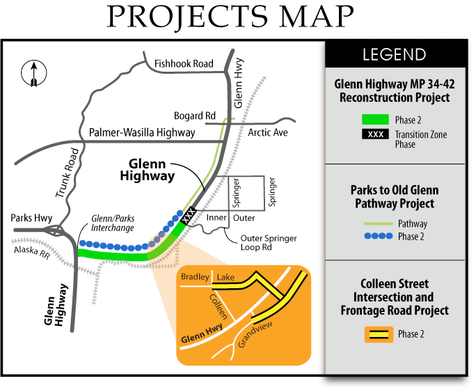
The Glenn Highway project consists of three distinct elements as listed below and shown on the map below. Full descriptions follow the map.
IRIS # Z581040000/Federal Project # NH-0A1-5(24) - TO TOP
Glenn Highway MP 34-42 Reconstruction Project
The Glenn Highway reconstruction project, Parks Highway to Old Glenn Highway, will reconstruct the Glenn Highway from milepost 34 to 42 to accommodate increasing traffic. It will add lanes, widen shoulders, accommodate turning movements at designated turn pockets, and add other traffic and safety improvements. The final roadway will be a four-lane divided highway.
The project is to be completed in two phases due to limitations of project funding, right-of-way acquisition and design challenges. Phase 1 construction is complete. The phases are listed below and shown on the following map:
- Phase 1 – South Inner Springer Loop to West Arctic Avenue is complete.
- Phase 2 –
Project is bidding in April 2023; construction will begin in summer 2023 following contract award to Granite Construction. Construction is scheduled to be complete September 2025.
IRIS # CFHWY00006/Federal Project # 0A15033 - TO TOP
Glenn Highway at Colleen Street Intersection and Frontage Roads
The Colleen Street Intersection and Frontage Road project is included in phase 2. The scope includes a traffic signal on the Glenn Highway to connect South Colleen Street and East Bradley Lake Avenue on the west side and East Grandview Road on the east side to the Glenn Highway.
This work is being tracked separately because it was not included in the original Environmental Assessment for the Glenn Highway MP 34-42 Reconstruction project. These improvements are planned to be included in phase 2.
IRIS # CFHWY00029/Federal Project # 0A15032 - TO TOP
Glenn Highway: Parks to Old Glenn Pathway
This pathway will construct a 10-foot wide separated pathway along the north side of the Glenn Highway starting at the Matanuska Lake State Recreation Area and extending into Palmer.
The project is planned to be split into two phases due to limitations of project funding and design challenges. The phases are listed below and shown on the following map:
- Phase 1 – The pathway between South Inner Springer Loop to West Arctic Avenue is complete.
- Phase 2 – Project is bidding in April 2023; construction will begin in summer 2023 following contract award to Granite Construction. Construction is scheduled to be complete September 2025.
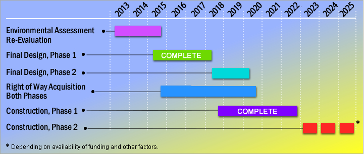
Project Schedule
All three Glenn Highway projects will follow the same design development, right of way and construction schedule. Construction of the final phase will occur in 2023 and complete in September 2025.
Project Documents
You must have Acrobat Reader to open most documents on this page. Download the FREE software. 1000 kb = 1 MB ![]()
Current Plans
- Glenn Highway Phase 2: (Parks Highway to South Inner Springer Loop) Alignment Sheets, Dated 4/2/23 - 3.5 MB
Current Fact Sheet
Current Fact Sheet - pdf
Glenn Highway Plans, September 2017
- Full Plan Set - 33.5 Mb
The following documents are available upon request.
- Final Design Study Report, dated April 2013
- Traffic Noise Analysis
- Right of Way Acquisition Brochure
- Approved Environmental Assessment Re-evaluation, August 6, 2015
- Environmental Assessment, 1993
Public Involvement
DOT&PF will relay accurate and timely project information to stakeholders, and consider their comments and concerns relating to design and construction traffic control. Contact the construction project team with any comments, compliments or questions.
Past Public Involvement Activities (documents available upon request).
November 9, 2023 - 2023 Mat-Su Transpotration Fair, 3-7 pm
Curtis D. Menard Memorial Sports Center, 1001 S Clapp St, Wasilla
Frequently Asked Questions
Questions
|
Answers |
1. Will you be installing flashing yellow arrows (FYA) at the traffic signals recently installed along the Glenn Highway? A. In response to community requests the Alaska Department of Transportation & Public Facilities (DOT&PF) department is investigating when to implement a Flashing Yellow Arrow (FYA) by time of day and volume on some of the smaller intersections on the Glenn Highway – (This means those with single left turn lanes in both directions). During times of normally low volume, FYA could be activated. At the busiest times of the day the left turns are expected to remain protected (solid green arrow) only. We understand and share the public's desire to move quickly to the better service the FYA will provide at low volume times. At the same time, FYA left turn signals require establishing consistent criteria to prevent serious crashes at peak traffic times. This criterion is not yet in place for higher speed multilane roads, therefore DOTPF must develop a reasonable method, which we expect to establish by summer 2021. We appreciate your patience as our team works to implement this new upgrade to Glenn Highway users. Determining the best hours for FYA operation on higher speed highways requires careful consideration and selection of appropriate hours. We will be conducting studies to determine typical volumes by time of day and comparing those volumes to the national experience and practice to develop our criteria for FYA operation. While national experience is primarily for use on urban roads, use on the Glenn Highway will require new criteria developed by DOT&PF. We will develop volume criteria for FYA operation and count the volumes on the Glenn during candidate times of day in order to determine and refine which hours FYA is appropriate. Activating this new light operation will take time. We have installed the new FYA heads and hardware. Our intent is to implement the FYA once practical safety and traffic volume thresholds are established. This will ensure consistent and safer use of FYA signals. Until the traffic counts are performed, and a criterion is established, the operation will be the same as it exists currently. For more information: http://dot.alaska.gov/stwddes/dcstraffic/fya/index.shtml |
2. Why is the website showing three projects? The original Glenn Highway Milepost (MP) 34-42 Reconstruction project, Parks Highway to Old Glenn Highway, was split into three projects to facilitate securing environmental clearance. The first project is the main reconstruction project which consists of two lanes in each direction, a frontage road, and left/right turn lanes. The second project will construct a multi-use pathway from Matanuska Lakes State Recreation Area to Arctic Avenue. The third project will realign the Colleen Street intersection and extend the frontage road. The pathway and realignment at Colleen Street were not included in the original Environmental Assessment for the project. Separate environmental documentation was completed for these projects. |
3. Why does the highway need widening? The Glenn Highway needs widening to accommodate current and future traffic and separate traffic to improve safety. A dominant crash type in the corridor is caused by vehicles crossing over into oncoming traffic. The widening allows the traffic to be separated and helps to mitigate this type of crash. |
4. There have been a number of fatalities on this road, how does this project help? The project helps reduce the number of fatalities on the highway by reducing two of the most dangerous types of crashes, cross-over crashes and left-turn related crashes. The grass median will provide more distance between opposing lanes and will reduce the number of head-on collisions. Dividing the highway will also reduce left-turn related crashes by eliminating left turning movements except at median openings. |
5. How will this affect me if I commute? Currently the highway can be congested at peak commute times by vehicles stopping in the through lanes to make left and right turns. The future roadway will provide an additional through lane in each direction and restrict left turning movements to signalized intersections or median openings. The new facility will accommodate future traffic volumes. |
6. Will it be easier for me to get onto the highway? Yes, it will be easier to get on the highway, however, your access and routing may change. To improve safety on the highway, right turning traffic can enter from any driveway, but left turning traffic will need to route to a median opening or signalized intersection. Signals will be spaced approximately ½ mile apart. Frontage roads are being added to facilitate this routing change and provide access to businesses. Left-turning related crashes are one of the most dangerous types of crashes on the highway and it is part of the purpose and need of this project. |
7. How will pedestrians and bicyclists be accommodated on the new roadway? A 10-foot-wide separated pathway is planned along the north side of the Glenn Highway from Matanuska Lakes State Recreation Area into Palmer. It will have an asphalt surface and be separated from the edge of the Glenn Highway. |
8. How do you plan to handle the traffic signal at West Outer Springer Loop when the train is present? The traffic signal will be coordinated with the train gates, and will generally remain in green mode for the highway traffic when the train is present. The exception will be when a vehicle is detected on the west leg of the intersection, and then the signal will change to allow a green light for the west leg vehicles entering the Glenn Highway. |
9. Will the speed limit remain the same once the project is built? Yes, the roadway will continue to be signed at 55 miles per hour to the fairgrounds and 45 miles per hour from the fairgrounds through the City of Palmer. |
10. Will right-of-way be needed for the project? Will my property be affected? Yes, the project will require acquisition from adjacent parcels. The team is working with those affected property owners. |
11. How much will this project cost, and how will it be funded? The Glenn Highway projects are federally funded with approximately 93% coming from Federal funds and the remainder from State of Alaska matching funds. The estimated construction cost of the project is $73 million (as of October 2015). |
12. Once constructed, will the new section of highway be noisier than the existing road? DOT&PF completed a Traffic Noise Report as part of this project. The report examined noise impacts and is available on the project website on the documents page. Due to widening the Glenn Highway, highway noise will increase for those closer to the proposed alignment, and will decrease for those in areas where the roadway moves farther away. The results of the report’s analysis show, following project construction, highway noise is not predicted to exceed Alaska DOT&PF standards for noise abatement actions (meaning: construction measures that are necessary if noise levels are too high). |
13. When will construction start, and how long will it take to complete? Phase 1 construction began in 2018 and completed in 2020. Phase 2 construction will begin in 2021 depending on the availability of funding, the acquisition of the necessary right-of-way, and other factors. |
14. What can travelers and area residents expect during construction? Will the roadway ever be closed? Traffic will be allowed continued use of the corridor during construction, however, travelers should expect detours and flaggers. Closures may be necessary but typically are timed at off-peak travel hours. DOT&PF works to provide plenty of notice to travelers and area residents. Check the project status at alaskanavigator.org or sign up for 511 alerts and other information regarding the Glenn Highway on GovDelivery at https://public.govdelivery.com/accounts/AKDOT/subscriber/new? |
Project Contacts
Your questions and comments are important to us!
Please feel free to contact the project team.
Project Information
Use DOT&PF’s Alaska Project Exchange tools to learn more about all of DOT&PF’s active construction projects statewide!
- Want to know how construction will impact road traffic? Visit 511.alaska.gov
- Want to dig into the details about projects across the state? Visit dot.alaska.gov/construction
If you have questions or comments about the project, please contact:
Ericka Moore, P.E.
Construction Manager, DOT&PF
(907) 269-0450
ericka.moore@alaska.govConstruction Contractor: (907) 550-6415
Project Office: 425 E. Denali Street, Suite H, Palmer, AK (no mail service), (907) 745-0954
Construction Project Engineer: John WaisanenFor individuals requiring TTY communications, please contact Alaska Relay at 7-1-1 or 1-800-770-8973.
